
Screenshot-based geographic reasoning

GeoGuessr AI Solver and Coach for Every Round

Upload a GeoGuessr screenshot and use AI to study the scene like a careful player. Get a likely location, a confidence estimate, and an explanation of the visible clues behind the guess—from road markings and signs to vegetation, architecture, utility poles, and Google car meta.

Analyze a GeoGuessr screenshotUnderstand visual and regional cluesPractice without browser scripts

Results are visual estimates and should be checked against the visible evidence in the round.

AI-Created Scenes for GeoGuessr Clue Practice

These synthetic scenes are learning illustrations, not proof of solver accuracy. Use them to practice separating visible observations from geographic conclusions before analyzing real rounds.

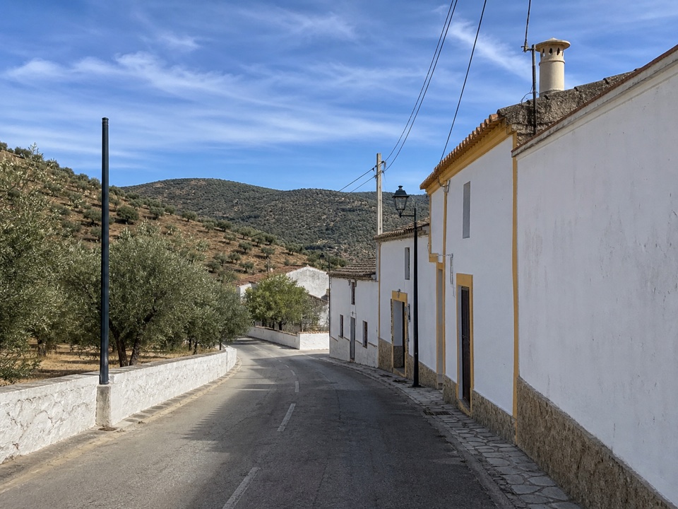
Dry village architecture and road context

Dry village architecture and road context

AI-created practice scene. Whitewashed walls, restrained yellow trim, olive-covered hills, narrow paving, curb construction, roof materials, and utility lines create a southern European hypothesis—but none of those clues alone proves a country.

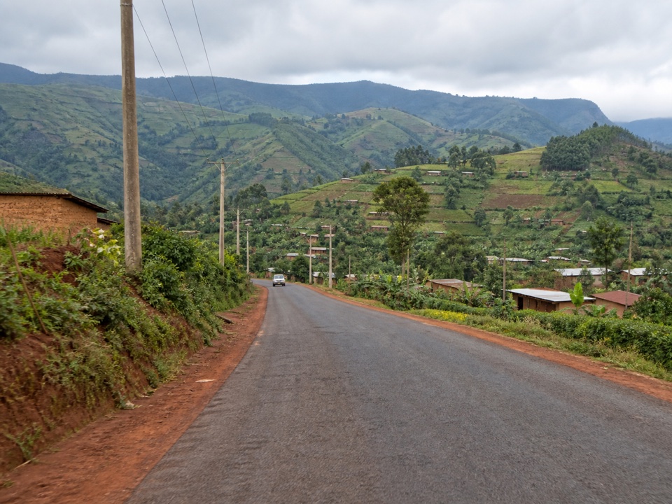
Highland agriculture, red soil, and infrastructure

Highland agriculture, red soil, and infrastructure

AI-created practice scene. Red shoulders, cultivated green ridges, settlement density, roof materials, pole construction, and road quality provide regional context. A careful solver should still look for traffic direction or country-specific infrastructure before committing.

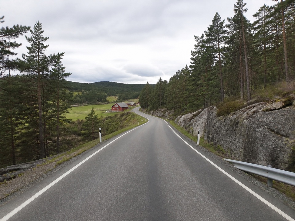
Nordic-looking road lines and delineators

Nordic-looking road lines and delineators

AI-created practice scene. Crisp white edge lines, black-and-white delineators, exposed gray rock, conifer forest, guardrail design, and red timber buildings form a useful clue cluster while still leaving several nearby countries plausible.

How It Works

How to Use the GeoGuessr AI Screenshot Analyzer

The web workflow is deliberately simple: provide the full visual context, let the model inspect different clue families, then compare the answer with what you can verify yourself.

1

Upload a clear round screenshot

Choose a JPG, PNG, or WebP screenshot that shows as much of the Street View scene as possible. A wider view usually preserves road edges, signs, poles, the Google car, and landscape context that a tight crop would remove.

Avoid covering the scene with menus, score panels, browser chrome, or oversized annotations when possible.

2

Let the AI compare clue families

The analyzer examines visible evidence such as traffic direction, road paint, sign systems, language, utility infrastructure, vegetation, terrain, buildings, and recognizable Street View capture details.

Several independent clues that agree are generally more useful than a single familiar-looking feature.

3

Review the guess and the reasoning

Use the suggested location as a working hypothesis. Read the supporting observations, identify the strongest clue, and consider which nearby countries or regions could share the same visual characteristics.

For practice, make your own guess before revealing the AI analysis and compare the reasoning afterward.

More Than a One-Word GeoGuessr AI Guess

A useful GeoGuessr AI solver should help you understand the round, not simply name a country. The analysis is organized around the decision a player needs to make and the clues that support it.

A likely country or region

Start with the most specific location the screenshot can honestly support. A distinctive city scene may allow a regional guess, while an ordinary rural road may only justify a country or broader area.

Confidence with context

Treat confidence as a summary of clue quality, not a promise of accuracy. Clear text, unique road infrastructure, and several clues pointing the same way deserve more confidence than one weak visual similarity.

Clue-based coaching

Read why road lines, driving side, bollards, camera generation, landscape, or architecture matter. The goal is to help you recognize the same patterns in future GeoGuessr rounds.

GeoGuessr Clues the AI Looks For

Strong geolocation comes from combining clue types. These are the recurring signals a GeoGuessr AI coach can inspect in ordinary city, suburban, and rural rounds.

Road lines and driving side

Center lines, edge lines, lane width, shoulder design, road surface, guardrails, and the side of traffic can eliminate large parts of the map before smaller details are considered.

Signs, language, and road shields

Scripts, place names, spelling, warning-sign shapes, route shields, sign colors, and signpost construction can indicate a language family, country, or specific road system.

Google car and camera meta

Visible mirrors, roof racks, antennas, snorkels, blur patterns, camera height, and image-generation artifacts may identify coverage associated with particular countries or Street View eras.

Bollards and street infrastructure

Roadside delineators, utility poles, hydrants, curbs, traffic lights, guardrails, and reflector designs are standardized locally and can be more reliable than scenery alone.

Architecture and settlement patterns

Roof materials, wall finishes, fences, setbacks, street grids, density, construction styles, and the relationship between buildings and roads can narrow a region.

Vegetation, soil, and terrain

Climate, crops, tree species, soil color, mountains, coastlines, drainage, and land use provide regional context, especially when a round has no readable text or famous landmark.

Accuracy and limitations

What a GeoGuessr AI Solver Can—and Cannot—Know

Image geolocation is an evidence problem. AI can organize subtle visual signals quickly, but no model can recover an exact location when the screenshot does not contain enough distinctive information.

Screenshots that support a stronger guess

  • Readable signs, road numbers, business names, or place names that can be connected to a language and road system.
  • A wide street view containing multiple independent clues, such as markings, bollards, poles, buildings, and landscape.
  • Distinctive coverage or car meta that is visible clearly enough to separate it from compression, cropping, and interface overlays.

Rounds that require more caution

  • Generic forests, unmarked roads, blurred suburbs, and similar agricultural landscapes can occur across many countries.
  • A confidence score is generated from the visible evidence; it is not a measured probability or proof of an exact coordinate.
  • Street View coverage changes, regional similarities, mirrored images, low resolution, and outdated meta knowledge can all mislead an analysis.

Use the solver as a study partner and second opinion. Important competitive decisions should follow the rules of the room, league, or tournament you are playing in.

Ways to Practice With a GeoGuessr AI Coach

The most useful workflow is repeated learning. Analyze different kinds of rounds, compare the explanation with your own reasoning, and build a mental library of clues you can recognize without assistance.

Review difficult NMPZ rounds

Use a single static screenshot to study what remains when moving, panning, and zooming are unavailable. Focus on broad road, coverage, infrastructure, and environmental signals.

Compare similar countries

Examine why two plausible countries differ. Road edges, pole materials, bollards, driving side, sign backs, roof styles, or soil can break a tie that scenery alone cannot.

Build a repeatable clue routine

Check the same categories in the same order on every round: camera and car, road, signs, infrastructure, buildings, vegetation, terrain, and finally regional fit.

Turn mistakes into study notes

After a wrong guess, record the decisive clue you missed and the misleading clue you overweighted. This makes the analysis useful beyond a single game.

Practice country recognition

Use varied urban and rural screenshots to learn national road systems, common coverage, languages, utility design, and climate zones before attempting precise regional guesses.

Improve regional guessing

Once the country is plausible, compare terrain, settlement density, architecture, coastlines, agriculture, and road quality to decide whether the image supports a region or city.

GeoGuessr AI Solver FAQ

Straight answers about screenshot analysis, visual clues, accuracy, fair use, image requirements, and how this web-based GeoGuessr AI tool differs from a generic location finder.

1

What is a GeoGuessr AI solver?

A GeoGuessr AI solver analyzes a screenshot from a geographic guessing round and estimates the likely country, region, or city from visible evidence. A coach-style tool also explains which road, sign, camera, infrastructure, architecture, and landscape clues influenced the answer.

2

Can AI solve a GeoGuessr round from one screenshot?

Sometimes, but the possible precision varies. A clear sign, unique road system, recognizable Google car, or distinctive landscape can support a strong country or regional guess. A generic road with no unique evidence may only support a broad, low-confidence estimate.

3

Does the GeoGuessr screenshot analyzer read GPS or EXIF data?

No. Screenshots normally do not preserve useful camera GPS metadata. This workflow analyzes what is visibly present in the pixels, including text, roads, infrastructure, buildings, vegetation, terrain, and Street View capture characteristics.

4

What image should I upload for the best analysis?

Upload the clearest, widest screenshot available. Keep road markings, signs, poles, the horizon, nearby buildings, and any visible part of the Google car in frame. Heavy crops, compression, motion blur, menus, and overlays remove useful context.

5

Can the AI recognize car meta and bollards?

A capable vision model can describe visible roof racks, mirrors, snorkels, antennas, camera artifacts, bollards, and other roadside infrastructure. Those observations still need context because similar objects, blurred imagery, and changing coverage can produce false matches.

6

Is a GeoGuessr AI coach the same as a browser cheat or script?

No browser injection or game-state extraction is required here. You manually upload an image for visual analysis. Whether outside assistance is allowed depends on the rules of your game, challenge, league, or tournament, so use it for learning and post-round review when assistance is restricted.

7

How is this different from a general AI image location finder?

A general finder tries to name a place from landmarks, text, and scenery. A GeoGuessr-focused analyzer also organizes game-specific clues such as coverage meta, road-line conventions, bollards, utility poles, sign backs, driving side, and country-comparison reasoning.

8

Is MagicCreator affiliated with GeoGuessr?

No. MagicCreator is an independent tool and is not affiliated with, endorsed by, or sponsored by GeoGuessr or its developers. Product and company names belong to their respective owners.

Analyze Your Next GeoGuessr Screenshot

Upload a round, inspect the likely location, and learn which visual clues can make your next independent guess stronger.